Will climate change in the Arctic increase the landslide-tsunami risk to the UK?
What are landslide-tsunamis and why are they important?

Worldwide, tsunamis are mainly caused by large earthquakes near plate boundaries, such as the 2004 Indian Ocean tsunami, and 2011 tsunami offshore Japan. Tsunamis can also be sourced by large underwater landslides, but these landslide-tsunamis are far less frequent than those caused by earthquakes. However, landslide-tsunamis may represent a greater threat to the UK, which is located away from the plate boundaries that create large earthquakes.
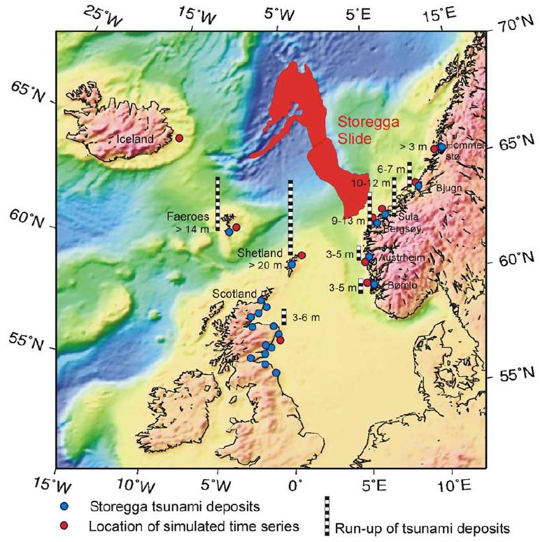
The Storegga Slide, a submarine mega-landslide that occurred 8,200 years ago offshore Norway, generated a tsunami that ran up to heights of three to six metres along northern parts of the UK coastline (see run-up heights in the figure to the right from Bondevik et al., 2005). A modern day event of a similar scale to the Storegga Slide would be likely to cause significant loss of life and devastating damage to key infrastructure. There are few other natural events that could have such a disastrous impact on the UK.
What are submarine landslides?
Submarine landslides are one of the volumetrically most important processes for transporting sediment across the continental shelf, slope and into the deep ocean. Submarine landslides can be much larger (two orders of magnitude) than those on land. For example, the Storegga Slide off Norway affected an area larger than Scotland, and the amount of sediment it mobilised is enough to cover Scotland to a depth of 80 m. Such gravity driven downward movement of slope-forming material can occur at all inclined areas of the seafloor. Landslides in shallow water (<200m water depth) can often be linked to cyclic tide or storm wave loading, whereas fjords are subject to frequent small failures along their steep walls. Slope failures related to volcanic island flank collapses involve a complex interplay of subaerial and submarine components along steep slopes with high relief. The largest of all submarine landslides occur on nearly flat (<2º) continental slopes. Since the volume of mobilised material in a landslide is a critical parameter for tsunami generation, these enormous landslides are potentially highly tsunamigenic.

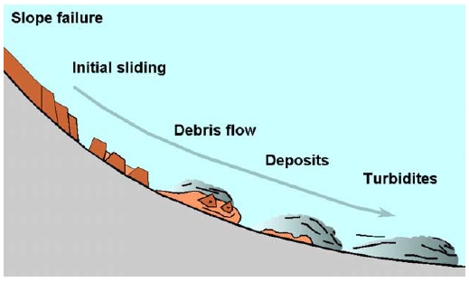
The sketch to the left shows the evolution of a submarine landslide on its way from the continental slope to the abyssal plain (after Bryn et al., 2005). On its downslope journey, the slide mass itself remains intact, breaks up into distinct blocks or deforms internally. In some cases the mass disintegrates as it moves downslope along the failure plane due to turbulence and water intake. A cloud of suspended particles forms and divides into a debris flow at the bottom and a turbidity current on top. The debris flow travels faster on steeper portions of the slope but stops eventually due to frictional forces, whilst the turbidity current can travel very long distances until turbulence decreases below a critical value. The potential of a slide to transform into these sediment flows, as well as the flow’s intensity and run-out distances, depend on a number of factors, e.g., the density of the failed material, its initial excess pore pressure, whether the material is contractive or dilational and its sensitivity, i.e., the amount of shear strength that is lost when the material fails.
Landslides in the Arctic

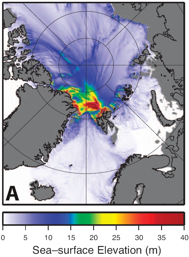
Submarine mega-landslides near to the UK have been very rare and it is thought that only six have occurred beneath the Norwegian and Greenland Seas during the last 20,000 years. It is not yet clear whether all of these mega-landslides generated large tsunamis, and not all landslide-tsunami source locations pose a threat to the UK. For example a tsunami with a source off north-west Svalbard travels towards northwards and would not be noticed along UK coast lines (see figure to the right from Vanneste et al., 2011).
It has been proposed that mega-landslides could become more frequent due to present and future climate change, to which the Arctic is sensitive to. Ocean warming causes melting of gas hydrate (crystalline solids resembling ice that contain methane), which weakens sea floor sediment. Melting of ice sheets will cause an increase in the frequency of large earthquakes, as the Earth’s crust adjusts to the removal of the ice sheet’s weight. These factors, or a combination of both, could cause large submarine landslides that may be tsunamigenic.
Why is more research needed?
A key point for hazard assessment is that submarine mega-landslides are much more poorly understood than almost all other types of natural hazard, such as river floods or storm surges. Underwater landslides can be far larger than any landslide seen on land. For example, the Storegga Slide offshore Norway affected an area larger than Scotland. It contained over 3,000 km³ of material (300 times the amount of sediment carried each year by all of the world’s rivers combined) and ran out for 800 kilometres into the deep ocean. Submarine landslides are not only remarkable due to their enormous size, but also because they occur on sea floor slopes of just one or two degrees - similar to the gradient of a Premier League soccer pitch. Hillsides with such remarkably low gradients are almost always stable on land, and it is not yet clear why submarine landslides occur on such low gradients. A second major uncertainty is how submarine mega-landslides are set in motion and whether they occur in one or multiple stages. This is important because the way in which the landslide moves determines the size of the tsunami it produces. Landslides that occur in a series of smaller discrete stages produce much smaller tsunamis.
What do we do?
The specific aims of the research project are four-fold:
- to determine the frequency and timing of major Arctic submarine slides;
- to better understand trigger factors and assess whether the frequency of the slides is likely to increase as climate changes and oceans warm;
- to assess the magnitude necessary for landslide-tsunamis to flood parts of the UK coast
- to quantify the likely cost to the UK of different types of inundation triggered by different types of landslide occurring in different locations.
The project uses a range of techniques, including shipboard expeditions that will map the Arctic seafloor and extract sediment cores from the seabed, fieldwork on land to identify and date coastal tsunami deposits, slope stability modelling, laboratory experiments showing how hydrate dissociation affects sediment strength, and modelling of future trends in seismicity. Also included is modelling of landslide motion, tsunami wave generation and propagation, and how tsunami waves would interact with existing UK coastal defence structures. Based on these results recommendations on measures that can be taken to offset a tsunami's impact on the UK coast can be given.Finally, a sensitivity analysis will aim to capture uncertainties, and determine societal cost.
The science team works closely with stakeholders, including government bodies (the Scottish Government and Defra, the Environment Agency) and the reinsurance sector.


